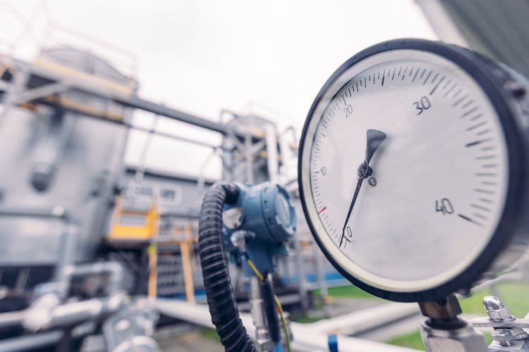
Natural gas utility pipeline monitoring and maintenance involve various challenges ranging from technical and regulatory to environmental parameters, reflecting the complexity and critical nature of managing transmission and distribution infrastructure. It requires periodic or near-real-time tracking to ensure safety, integrity, and efficiency in its end-to-end operations. Some of the key risks associated with gas pipelines include leak and localization, environmental factors such as weather conditions, natural or man-made disasters, encroachments such as vegetation, excavations, built-up structures, frequent changes in regulatory compliance parameters, and complex terrains that run for miles, which involve time and effort-intensive field visits. Disparate non-integrated systems in the enterprise are another key reason for near-real-time monitoring and planning contingency or mitigation plans.
GeoAI has shown huge potential in pipeline monitoring and management and has been implemented by many oil and gas customers. It uses satellite or drone imagery to enable planning and near-real-time monitoring from anywhere without the need for a cumbersome field visit. According to Morgan Stanley, Earth Observation (EO) data is projected at $25.273 billion by 2040 with a CAGR of 8.3%. GeoAI is estimated at a staggering 12.2% CAGR, soaring from $67.4 billion in 2022 to $119.9 billion by 2027, as per M&M.
Pipeline route planning typically involves analysis over a set of constraints—physical barriers like existing land use, water bodies, reserve forests, and built-up areas—regulatory and environmental guidelines, including bio-diversity parameters and available alternative routes, to arrive at a decision in selecting an optimal path for laying the pipeline. GeoAI, with a set of algorithms such as multi-criteria multi-objective analysis, least path analysis, and predictive models using satellite imagery, helps in spatial decision-making in best route identification to ensure socio-environmental and regulatory compliance and optimal cost.
Monitoring is the other key activity in the pipeline management value chain, which often calls for near-real-time tasking-based frequent periodic surveillance of assets.
Gas Pipelines Risks
- Safety hazards: Safety is a top concern in gas utility operations. The risk of accidents, such as leaks, ruptures, or explosions, poses a significant threat to the public, personnel, and infrastructure.
- Gas leaks and emissions: Uncontrolled gas leaks can result in environmental pollution, contribute to climate change, and pose health risks.
- Pipeline corrosion: Corrosion of pipelines over time can weaken the infrastructure, leading to leaks or structural failures.
- Integrity management failures: Inadequate monitoring and assessment of pipeline integrity may lead to undetected issues, increasing the risk of failures. Failure to properly manage integrity can result in safety incidents and regulatory non-compliance.
- Technology failures: Dependence on technology for pipeline monitoring introduces the risk of equipment failures or malfunctions. The loss of monitoring capabilities can impede timely response to potential issues.
- Natural disasters: Natural disasters such as earthquakes, floods, or landslides can damage pipelines, leading to leaks or ruptures. Gas utilities must consider and plan for these events to minimize the associated risks.
- Security threats: Gas pipelines may be vulnerable to security threats such as terrorism, vandalism, or theft. These incidents can lead to safety hazards, environmental damage, and disruption of gas supply.
- Regulatory non-compliance: Gas utilities must comply with regulatory requirements to ensure safety, environmental protection, and operational standards. Non-compliance can result in fines, legal issues, and damage to the company's reputation.
- Operational disruptions: Unplanned shutdowns or disruptions in gas supply can have significant economic and social consequences. These disruptions may result from accidents, maintenance issues, or external factors beyond the utility's control.
- Data security and cyber threats: As gas utilities rely on digital technologies for monitoring and control, the risk of cyber threats increases. Unauthorized access to control systems can lead to operational disruptions and compromise safety.
- Environmental impact: Gas leaks can have long-lasting environmental consequences, including soil and water contamination. Addressing and mitigating the environmental impact of incidents is essential to minimize long-term risks.
GeoAI uses earth observation (remote sensing technologies—satellites, drones, sensors, and others) to collect data about the earth's surface and atmosphere and monitor and analyze various aspects of asset and risk monitoring using machine learning algorithms. In the context of Geospatial AI, machine learning enables automated analysis of large and complex datasets, identifies patterns and anomalies, and makes predictions about future trends. For example, machine learning algorithms can be trained to detect and classify different types of risks.
Role of GeoAI in Risk Mitigation
GeoAI has successfully addressed the following risks:
- Surveillance of any encroachments along the right of way (RoW) of pipelines like construction work and machinery, built-up areas, buildings, storage of materials and equipment, digging and excavation, and other human activities or other unauthorized risks that generally violate both overhead and underground assets, is critical. High-resolution satellite imagery and advanced machine learning algorithms help accurately identify these encroachments and changes that may violate infrastructure. Machine learning algorithms help detect critical assets and plan contingency and mitigation actions. Imagery from different types of sensors (multi-spectral optical, all-weather Synthetic Aperture Radar or high spectral-precise “hyperspectral” data) is utilized in combination or alone with AI/ML to enable surveillance.
- Pipeline integrity monitoring: Here, Ground Penetrating Radar (GPR) for underground assets and Synthetic Aperture Radar (SAR) all-weather imaging augmented with optical multispectral data that includes thermal bands help to monitor ground or sub-surface deformations, subsidence, or any changes in the landscape.
- Pipeline-related ground and structure motion monitoring is another key challenge. With integration of time series InSAR, radar interferometry from SAR reflectors or transponders it helps monitor and predict displacement along pipelines in relation to landslip, river crossing, or tectonic hazard zones using the persistent scatterer interferometry (PSI) technique.
- Vegetation growth along the pipeline right-of-way poses a risk of root intrusion that may lead to greenhouse gas (GHG) leaks. Regular monitoring of vegetation using high spectral resolution satellite imagery can help locate vegetation and take timely action. Further, a Vegetation Growth Machine Learning model using several parameters such as vegetation type, time series data on its health, height, wind speed, soil moisture, and temperature, along with satellite imagery, helps predict the growth of vegetation and encroachment. This, followed by an automated scheduling for preventive action downstream, helps fix the problem well in advance.
- Accurately detecting and localizing gas leaks early along the pipeline is critical for this industry, considering the gas itself and the pipeline’s reach across vast distances in largely suburban and inaccessible locations. GeoAI with high-resolution time series hyperspectral imagery augmented with specific GHG satellites (ex https://www.ghgsat.com/en/) helps identify potential gas leaks by detecting anomalies or signatures, including vegetation stress, soil discoloration, or thermal signatures.
GeoAI and Climate Change Challenges
Climate change has been a key factor leading to unpredictable and frequent changes in weather conditions—landslides, floods, extreme cold or hot temperatures—that become a challenge in the delivery of natural gas while ensuring network reliability and uninterrupted service to customers. Extreme heat and cold, heavy rains, and windstorms can drastically damage utility pipelines and associated infrastructure assets. Extreme cold may lead to challenges in the downstream transport of gas in the pipeline. Environmental satellites have been effective in monitoring and maintaining the safety and reliability of critical infrastructure assets by providing accurate and timely information on environmental variables, such as temperature, precipitation, wind speed and direction, and more. This helps operators utilize other relevant satellite imagery for further analytics in making informed decisions about infrastructure design, maintenance, and emergency response in order to improve the resiliency and reliability of critical infrastructure. Multi-band optical and SAR satellite imagery augmented with specific almanac data—wind speed, temperature, precipitation, wind direction, wind gust speed, relative humidity, and soil moisture—help predict the impact on assets ahead of its occurrence and enable planning for mitigation.
Spatio-temporal synthetic aperture radar data has been effectively used to predict risks such as landslides, ground movements, erosion, and land displacement that cause the destruction of critical assets such as ruptured or destroyed pipelines, leading to disruptions in supply and transportation. Satellite imagery-based AI/ML models are used to predict possible damages regardless of weather or accessibility conditions. Several derived parameters such as slope, aspect, relief, weather, and others, along with satellite imagery, are used together to train a model on land or asset displacement and detect and plan contingency and mitigation actions.
Hyperspectral imaging, which captures finer details with numerous spectral bands, helps carry out a variety of spatial requirements on chemical and textural composition in several aspects, including vegetation, agriculture, geology, soil, water resources, disaster, and land use monitoring and management.
Hence, addressing the challenges in pipeline monitoring and management requires a holistic approach that combines advanced technologies, including earth observation and other terrestrial data, along with industry best practices on regulatory and environmental compliance in early detection to ensure the safety and reliability of gas pipelines. Earth observation and or drone-based monitoring has been solving this successfully by having a GeoAI-enabled solution that provides end-to-end execution from data tasking, capturing, preprocessing, and processing to knowledge extraction and presenting the critical locations or regions. A typical end-to-end execution pipeline is shown below. Based on specific use cases, the models are trained with a set of spatio-temporal data.
Cyient’s GeoAI Solution
Cyient’s GeoAI solution is built an MLOps platform that captures data in near-real-time from diverse EO sources and a set of Machine Learning features with end-to-end orchestration and execution from a seamlessly integrated unified interface. The execution pipeline is depicted below.
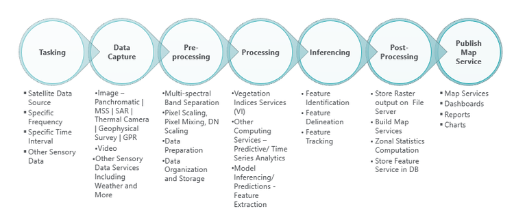
With advances in earth observation technology and CubeSats deployments, over a thousand satellites are operational today, orbiting the earth and capturing petabytes of diverse data 24x7—a panchromatic aerial imagery to multi-spectral, hyperspectral, SAR, thermal infrared, and others. This is often backed up with aerial using drone or terrestrial Point Cloud or 360o Panorama/multi- or hyper-spectral or thermal camera for capturing fine-grained detail for specific sub-region of interest. Further, there are huge improvements in the quality and efficacy of data in terms of radiometric, temporal, and spatial resolution, thus increasing the volume of data.
AWS, Google, and Azure Earth Observation services have streamlined the way data is ingested, transformed, and delivered with extracted knowledge to enable customers to make decisions effectively and efficiently in near-real-time. This makes platformization the backbone for enabling organizations to be solution-driven rather than services-driven, holding up space as one of the megatrends of the decade.
With continued enhancements in spectral and temporal resolution and augmentation with IIOT and other enterprise systems along with advanced AI/ML algorithms, natural gas pipeline monitoring has a bright future. The features of comprehensive coverage, real-time monitoring capabilities of earth observation, and its integration with other sensory and enterprise data are transforming the approach to planning, managing, and maintaining pipeline corridors.
With its focus on the sustainability megatrend and promoting a greener tomorrow, Cyient offers GeoAI solutions with varied geospatial data from diverse and disparate sources. It provides effective and efficient location-intelligent solutions for its customers while enabling increased operational safety, productivity, and reliability, along with regulatory and environmental compliance.