In this concluding installment of our two-part series on Location-Based Services (LBS), we build on insights shared in Part 1 — available here.
From Maps to Intelligence: The LBS Evolution
LBS has evolved from basic asset-tracking tools to intelligent, real-time enablers of decision-making. As industries shift toward hyper-connectivity and automation, LBS is becoming central to transforming field operations. Moving beyond traditional GIS workflows, modern LBS integrates AI, edge computing, geofencing, AR wearables, and digital twins to empower crews with context-aware, predictive, and automated capabilities.
Organizations across sectors like utilities, infrastructure, healthcare, and logistics, are shifting from reactive workflows to spatially intelligent ecosystems. Companies like Cyient are piloting LBS-integrated solutions for disaster response, predictive maintenance, and crew visualization.
Emerging innovations, such as 5G-enabled LBS, satellite IoT, and cloud-native platforms like Google Earth Engine and AWS SageMaker are laying the groundwork for ultra-responsive, real-time field operations.
What’s Holding Field Ops Back? Despite advancements in GIS and mobile connectivity, many organizations still face critical challenges in their field operations. Understanding these roadblocks is key to unlocking the full potential of location intelligence.
- Delayed hazard detection due to lack of real-time geospatial context
- Fragmented team coordination, especially during emergencies
- Manual workflows that increase errors and reduce productivity
- Limited HMI tools that hinder task execution in complex or low-visibility environments
- Underutilization of location intelligence for dispatching, routing, and decision-making
How LBS is Powering Smarter Field Operations:
With these challenges in mind, let’s look at how advanced LBS implementations are helping organizations shift from reactive responses to proactive, data-driven action on the ground.
- Context-Aware Emergency Routing: Real-time hazard overlays (e.g., floods, fires) using Copernicus EMS, OpenRouteService, APIs, and satellite imagery enable dynamic, safer navigation.
- AR Wearables for Field Guidance: Smart helmets and AR glasses (e.g., Trimble XR10, ArcGIS Indoors) provide overlays of utilities and hazards, enabling hands-free, voice-guided operations.
- Autonomous Robotics: SLAM-enabled drones and ground robots feed real-time data into GIS, supporting inspection, vegetation analysis, and safety in high-risk zones.
- AI for Predictive Intelligence: AI models trained on LBS data anticipate risks, failures, and optimal routes, enabling proactive planning and improved field readiness.
Industry Spotlight: LBS in Action:
From healthcare to logistics, the impact of LBS is being felt across diverse industries. Here’s a glimpse at how different sectors are tailoring LBS for specialized field outcomes.
The Tech Behind the Transformation:
These real-world applications wouldn’t be possible without cutting-edge technologies working behind the scenes. Here's what drives this transformation:
-
Spatial Edge Computing:
Devices like Azure Percept and NVIDIA Jetson process spatial data onsite for instant insights like gas leak or terrain anomaly detection.
-
Digital Twin Feedback Loops
Real-time LBS updates from LiDAR or drones enrich digital twins, enabling virtual simulations before field deployment.
-
Real-Time Geofencing for Workflow Automation
Platforms like ArcGIS Location Tracking and FME Server automate inspections and alerts when crews cross operational boundaries.
-
Satellite IoT + GNSS Precision Tracking
Sub-decimeter accuracy via GNSS (Galileo, BeiDou) and LEO constellations (e.g., Starlink) ensures coverage in remote areas, key for mining and logistics.
Integrated Application Scenarios:
Often, it's not a single technology but a well-orchestrated combination that delivers results. The following scenarios highlight how integrated tech stacks enable smarter, seamless field execution.
-
Scenario
- Urban excavation permitting
- Emergency vehicle routing
- Smart campus/airport maintenance
- Maritime logistics optimization
- Cross-border logistics
- Disaster damage assessment
-
Technology Stack
- AR + 3D GIS + LBS from utility DBs
- LBS + CCTV overlays + Live hazard heatmaps
- Indoor positioning + BLE beacons + LBS-triggered task automation
- Satellite AIS + Geofencing + Customs clearance APIs
- Real-time GPS + Route status alerts + Smart checkpoint systems
- UAV + LBS + AI classification on GEE + Crowdsourced geotagged photos
LBS That Delivers: The Numbers Speak
Beyond innovation and use cases, the value of LBS is best shown through measurable outcomes:
- 50–70% reduction in blind spots via spatial alerts and real-time mapping
- Up to 80% faster resolution through AI-optimized routing
- 20–40% improvement in asset protection using geofencing and real-time tracking
- Increased crew productivity through AR and hands-free navigation tools
What the Future Holds for Smart Field Ops
The fusion of LBS with AI, geospatial analytics, and automation is turning static GIS into real-time intelligence systems. From AR wearables and autonomous drones to spatial edge computing, LBS empowers safer, smarter, and more efficient field operations.
Cyient’s collaboration in co-developing these solutions exemplifies how modern LBS ecosystems create connected, resilient, and future-ready field environments.
Ongoing innovations in AI, satellite IoT, and 5G-enabled LBS will continue to expand the frontiers of geospatial intelligence.
Ready to Make Field Ops Smarter? Start Here!
To stay competitive and future-ready in field operations, it is essential to transition from static asset tracking to contextual LBS systems that provide real-time situational awareness and decision-making support.
- Adopting spatial edge computing allows organizations to process data at the source, enabling faster onsite risk assessments and minimizing dependency on central systems.
- Deploying augmented reality and geofencing automation can significantly improve inspection accuracy and operational compliance.
- Collaborating with geospatial technology leaders like Cyient presents an opportunity to co-develop scalable, intelligent ecosystems tailored for dynamic field environments.
- Expanding into satellite IoT and cloud-native platforms enhances operational resilience, especially in remote or infrastructure-limited regions.
- Finally, integrating AI models within LBS workflows helps unlock predictive insights, enabling proactive management of assets, risks, and resource allocation.
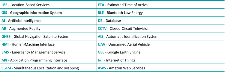
Glossary of Abbreviations: