
Spatial AI adoption is accelerating across sectors that depend on geographical accuracy and contextual awareness. Models trained on satellite imagery, LiDAR point clouds, UAV data, and enterprise GIS are no longer confined to analytical exploration. They are embedded directly into operational workflows, informing infrastructure planning, grid reliability, environmental monitoring, emergency response, and risk assessment.
As spatial intelligence begins to shape priorities, budgets, and on-ground interventions, the nature of operational risk changes. These systems interact directly with physical terrain, built assets, and population distributions. Their output directly influences where inspections are conducted, which risks are escalated, and how services are deployed. In this operating context, errors are not theoretical. They manifest as safety exposure, financial loss, service disruption, and erosion of stakeholder trust.
At this stage of adoption, the question is no longer whether to use spatial AI, but how to govern it responsibly at scale.
The Distinctive Risk Profile of Spatial AI
Although spatial data is often perceived as objective, it reflects how, where, and why the data is collected. Coverage density, sensor availability, update frequency, and historical investment patterns all shape what models learn. As a result, spatial AI inherits risks that are fundamentally geographic in nature.
- Systemic Spatial Bias is Structural, Not Accidental
Most large-scale spatial training datasets are concentrated in urban and data-rich regions, supported by high-resolution imagery, dense sensor coverage, and frequent refresh cycles. Rural areas, forested landscapes, coastal zones remain comparatively underrepresented.
When models trained on such imbalanced data are deployed across diverse geographies, performance degradation is common. Missed asset detections, inaccurate land-use classifications, and unreliable risk scoring are frequent outcomes. The underlying issue is not algorithmic capability, but uneven spatial representation in training data. This makes spatial bias systemic rather than incidental and a governance issue rather than a tuning exercise. - Geography Can Quietly Act as a Proxy for People
Location often correlates with socio-economic conditions, even when demographic attributes are not explicitly present in the data itself. When spatial models infer risk, priority, or value primarily from geographic patterns, unintended demographic bias can emerge.
This is particularly consequential in infrastructure investment, disaster response planning, and urban development, where learned spatial correlations may reinforce historical underinvestment or uneven service distribution. Because these effects propagate quietly through automated workflows, explicit governance mechanisms are essential for detection and mitigation. - Error amplification in operational contexts
In research or benchmarking contexts, modest error rates may be acceptable. In operational environments, the same errors can cascade quickly. Spatial outputs increasingly feed dashboards, alerts, and executive decision tools. Even small misclassifications can escalate into incorrect flood zoning, delayed emergency response, or inefficient outage prioritization. As spatial intelligence moves from maps to mandates, tolerance for error narrows sharply.
Why Generic AI Governance Falls Short for Spatial Intelligence
Most AI governance frameworks emphasize accuracy, privacy, and explainability. These dimensions are necessary, but insufficient for spatial intelligence.
Spatial systems operate in environments that change continuously through seasonal variation, urban growth, land-use shifts, and infrastructure development. Sensor technologies evolve, altering resolution, coverage, and revisit rates. Spatial relationships - proximity, adjacency, and connectivity, directly influence analytical outcomes.
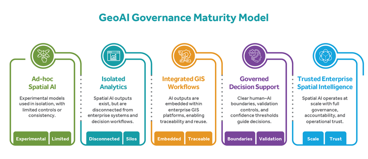
Effective governance must therefore extend beyond models to encompass spatial workflows, data lifecycles, and decision pathways.
Where Spatial AI Governance Becomes Non-Negotiable
Governance becomes essential wherever spatial AI directly shapes operational priorities, safety outcomes, regulatory exposure, or financial risk. This includes:
-
Utilities and linear infrastructure operations
-
Transportation and mobility infrastructure
-
Disaster risk management and emergency response
-
Environmental and climate risk analytics and monitoring
-
Smart urban infrastructure management
-
Insurance-driven infrastructure risk assessment
In these domains, analytical errors propagate into physical systems and human outcomes. Governance is not a control overhead; it is a prerequisite for operational confidence.
A Four-Layer Governance Framework for Spatial Intelligence
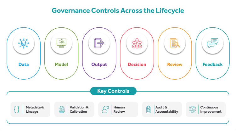
To address these challenges, a practical four-layer governance framework is proposed. It is designed to be reusable across industries while remaining grounded in real operational workflows.
- Data Governance: Establishing Trust in Spatial Inputs
Data governance forms the foundation of reliable spatial intelligence. This includes standardized spatial annotation definitions, documentation of geographic coverage and gaps, structured handling of edge cases such as occlusions or mixed land cover, and periodic retraining to account for temporal change.
Spatial training data is inherently volatile; treating it as a static deliverable increases the risk of performance degradation and bias over time.
In enterprise environments, trust is reinforced through interoperability and metadata practices. Adherence to open geospatial standards enables consistent integration across platforms, while standardized lineage and metadata descriptors support traceability, reproducibility, and auditability as insights move from analysis into operations. - Model Governance: Establishing Trust in Spatial Reasoning
Model governance focuses on how spatial patterns are learned and generalized. Region-wise validation is essential, as random data splits fail to capture geographic variability. Explainability techniques must highlight spatial drivers, not just abstract feature importance scores.
Continuous monitoring across terrain types and land-cover classes enables early detection of localized performance drift. A model that performs well globally may still fail in specific regions without spatially aware controls. In high-impact environments, rigorous validation and calibration practices, using reference benchmarks and controlled datasets, help maintain measurement integrity as sensors, resolutions, and operating conditions evolve. - Decision Governance: Governing How Insights are Acted Upon
Decision governance defines how spatial outputs are used within operational workflows. Clear boundaries between AI recommendations and human judgment are critical, particularly in high-impact scenarios.
Confidence thresholds should determine when automation is appropriate, while scenario-based reviews should precede irreversible decisions. Spatial intelligence should augment human decision-making, not replace it without guardrails.
Oversight and Accountability: Clarifying Responsibility Oversight mechanisms ensure accountability across the full lifecycle. Audit trails linking data, models, outputs, and decisions provide traceability. Shared ownership between technical and business stakeholders prevents siloed responsibility, while periodic bias and impact reviews enable proactive, ongoing risk management. Accountability cannot be delegated to automated systems.
Enabling Governance through Spatial-First Capabilities
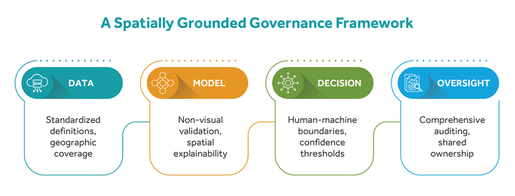
Responsible spatial AI is supported by capabilities such as spatial lineage tracking, audit logging, human-in-the-loop validation, region-aware testing strategies, and standardized geospatial metadata practices across the lifecycle. These practices strengthen transparency and trust without constraining innovation.
Operationalizing Governance with Cyient’s Geospatial Capabilities:
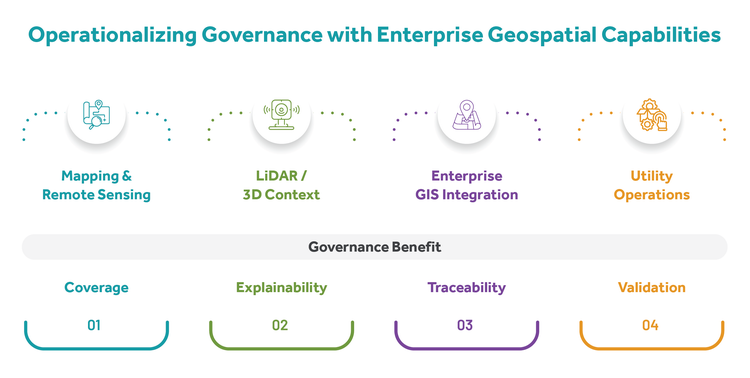
At enterprise scale, governance depends on a mature geospatial foundation that supports validation, traceability, and accountability across operational workflows. When spatial intelligence is embedded within operational workflows, governance shifts from principle to practice.
1. Advanced Mapping and Remote Sensing Foundations
High-definition base mapping and advanced remote sensing analytics form the foundation for governed spatial intelligence. Multispectral imagery, SAR analysis, and temporal change detection enable consistent, repeatable feature extraction across heterogeneous geographic contexts.
Case Study: In one representative context, a national utility company operating across South and Southeast Asia faced uneven imagery quality and strong seasonal effects across mixed urban–rural terrain. Spatial coverage analysis exposed geographic data gaps, while multi-season imagery ingestion helped reduced monsoon-driven bias. Temporal validation controls ensured detected changes reflected true asset variation rather than seasonal artifacts.
Outcome: improved coverage transparency, temporal relevance, and bias mitigation.
2. Lidar and 3D Spatial Modeling for Decision Fidelity
LiDAR-based 3D modeling adds structural context, improving both reliability and interpretability. High-fidelity point clouds represent terrain, vegetation, and complex built environments with greater precision.
Case Study: In a European transportation setting, reliance on 2D imagery led to high false positives in dense urban corridors. Introducing 3D context significantly reduced asset misclassification caused by overlapping infrastructure and improved spatial explainability. Decision thresholds could now be calibrated more effectively using height, clearance, and volumetric attributes.
Outcome: stronger model explainability and confidence-based decisioning.
3. Integrated Geospatial Analytics and Enterprise GIS
Embedding spatial AI outputs within enterprise GIS platforms enables end-to-end traceability across the spatial intelligence lifecycle. Governance becomes enforceable rather than procedural.
Case Study: In a North American infrastructure services environment, spatial insights were initially consumed outside formal workflows. GIS integration introduced structured review checkpoints, established audit trails for post-decision analysis, and clarified ownership across teams.
Outcome: traceability, reviewability, and clear ownership.
4. Utilities and Spatial Intelligence Integration
In utility operations, spatial intelligence sits directly within asset lifecycle management and grid reliability workflows. Governance must balance automation benefits with operational risk and regulatory expectations across utility operations.
Case Study: In a large transmission corridor context across desert terrain in the Middle East, AI-driven prioritization was deliberately positioned as decision support rather than automatic action. Human validation was enforced for high-impact interventions, and spatial risk zones were periodically reviewed to reflect environmental and operational change.
Outcome: lifecycle governance across data, model, decision, and oversight.
Innovation to Responsible Scale
Organizations that scale spatial intelligence responsibly share three characteristics: training data is treated as a strategic asset, analytical pipelines are designed for continuous monitoring and evolution, and ethical considerations are embedded within workflows rather than applied retroactively.
The Strategic Choice Ahead
Spatial intelligence will continue to transform how decisions are made across industries. The differentiator will not be speed of adoption, but the maturity of governance. Without governance, spatial AI creates blind spots and unmanaged risk. With governance, it becomes a foundation for trusted intelligence, supporting safer operations, stronger business outcomes, and more resilient systems. The choice is not between innovation and ethics. It is between fragile innovation and sustainable intelligence.
The next step is not another model. It is a governed spatial intelligence strategy that aligns data, technology, and decision-making into a single accountable system. If your organization is moving from spatial insight to spatial action, the time to design governance into the workflow is now. At scale, responsible spatial intelligence depends on traceability, governance maturity over speed, and sustained human oversight in high-impact decisions.
Explore how governed spatial intelligence can support your operational decisions. Get in touch with our experts to assess readiness, identify gaps, and chart a path to responsible scale: www.cyient.com/contact-us