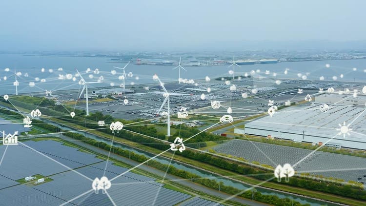
Renewable infrastructure planning is often optimized at the project level, but it falls short at the system level when geospatial intelligence is not fully integrated. Traditional approaches emphasize engineering feasibility and financial modeling, while underrepresenting spatial interactions across terrain, infrastructure, and demand patterns.
Based on projections as of early 2026, renewable energy is projected to account for nearly 40% of global electricity generation, yet grid congestion has delayed over 35% of new projects in the past year alone. These bottlenecks highlight the urgent need for smarter, interconnected planning. By leveraging geospatial intelligence, we can transform these challenges into opportunities, building systems that are not only robust and efficient but prepared for the next wave of rapid growth.
Rethinking Project Feasibility for System Performance
Renewable infrastructure development, including solar farms, battery energy storage systems (BESS), and grid expansion, is typically driven by engineering, regulatory, and financial considerations. While effective for individual projects, these approaches often fail to capture broader spatial dependencies that shape long-term performance.
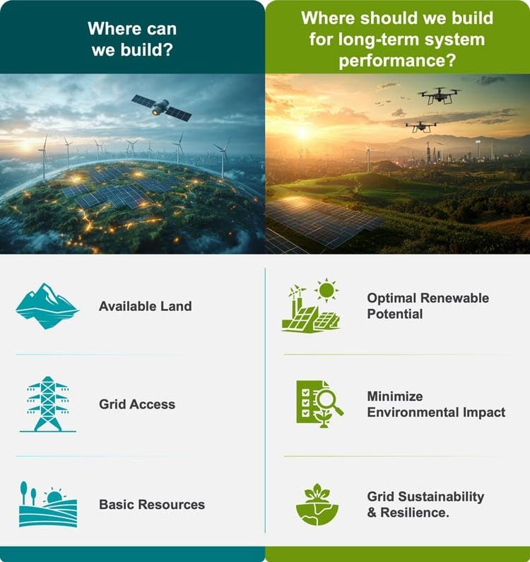
As renewable systems become more distributed and interconnected, isolated planning decisions can create downstream inefficiencies in grid integration, asset placement, and scalability. Renewable planning is therefore not only an engineering challenge. Renewable infrastructure planning is not only an engineering challenge, but also fundamentally a geospatial intelligence challenge. The key shift is:
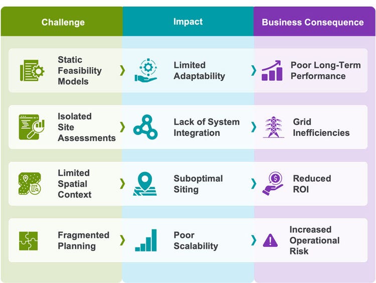
Why Traditional Planning Approaches Fall Short?
These challenges compound across the planning lifecycle, limiting the ability to evaluate interdependencies between generation, storage, and grid infrastructure. As systems scale, the result is often misaligned investment, inefficient asset utilization, and weaker overall performance.
Enabling Renewable Planning Through Geospatial Intelligence
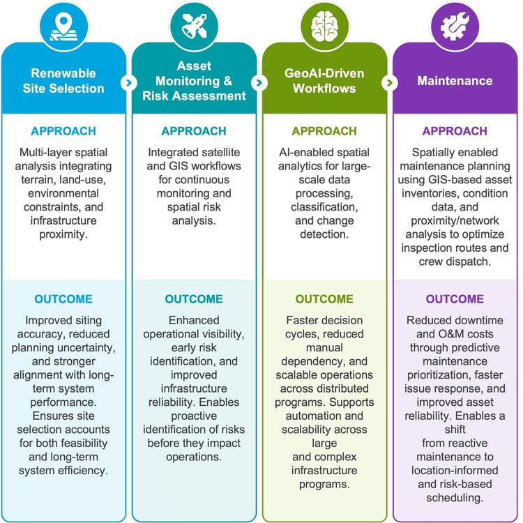
Rather than focusing solely on whether a particular site meets basic technical requirements, advanced geospatial analysis empowers decision-makers to consider the broader implications of each location within the entire energy network. By visualizing how individual projects interact with existing grid infrastructure, land use, and future demand, planners can proactively identify potential bottlenecks or synergies. This system-wide perspective supports the creation of more resilient, efficient, and future-ready renewable energy portfolios.
Use Case: In large-scale renewable programs, site selection decisions cannot be evaluated in isolation. A solar installation optimized for irradiation may face constraints in grid connectivity or land-use limitations. Proximity to demand centers may improve network efficiency, but it can also introduce trade-offs related to environmental or regulatory compliance. Geospatial intelligence brings these competing variables into a single planning framework, helping organizations move beyond isolated feasibility assessments toward more connected, resilient infrastructure strategies.
Core Capabilities for Smarter Planning
These capabilities form the analytical foundation for system-level, data-driven renewable infrastructure planning:
- Multi-variable suitability analysis → Identifies optimal locations by evaluating terrain, constraints, and infrastructure factors together.
- Spatial network modeling → Ensures efficient integration with grid infrastructure and demand centers.
- Temporal data integration → Accounts for climate variability and evolving demand patterns.
- Scenario simulation → Supports proactive, long-term planning through evaluation of future scenarios.
Scaling Geospatial Intelligence for Enterprise Planning
At the enterprise level, the challenge is not generating insights, but operationalizing them consistently across projects, regions, and workflows. Without integration into enterprise workflows, geospatial analysis remains fragmented and limited in its ability to influence planning outcomes, standardize processes, and support long-term infrastructure optimization.
In many organizations, planning approaches vary across regions, data standards remain inconsistent, and spatial insights often remain disconnected from operational systems. As a result, even well-developed geospatial analysis fails to consistently influence infrastructure planning decisions at scale.
Embedding geospatial intelligence within enterprise GIS platforms enables organizations to:
- standardize planning approaches across regions and projects
- integrate spatial insights into decision-support systems
- transition from one-time assessments to continuous monitoring and optimization
These capabilities are typically supported through enterprise GIS platforms such as ArcGIS Enterprise, ArcGIS Online, and QGIS, along with advanced processing environments including Google Earth Engine, ESA SNAP, and cloud-based geospatial analytics platforms.
This shift is particularly critical for organizations managing large, distributed renewable portfolios, where planning decisions must be consistent, repeatable, and aligned with long-term system performance.
It also supports a more mature approach to grid modernization, where planning intelligence is connected to operational realities across increasingly complex energy networks.
Implications Across Infrastructure and Utility Ecosystems
A geospatial intelligence-driven approach delivers measurable impact across infrastructure and utility ecosystems by enabling more informed, location-aware decision-making. These impacts extend across planning, operations, and long-term infrastructure management where spatial insights influence how assets are positioned, connected, and optimized within broader system environments.
-
Utilities can improve grid stability through spatially optimized network design, reducing transmission inefficiencies and enhancing operational reliability.
-
Infrastructure planning teams can align more effectively with industrial and transport corridors, enabling integrated and scalable regional development.
-
Urban systems can integrate distributed energy solutions more efficiently through GIS-based planning, supporting resilient and decentralized infrastructure.
-
Environmental planning teams can embed spatial constraints and ecosystem considerations directly into site selection, ensuring sustainable and compliant development.
-
Climate resilience programs can use spatial analysis of generation and demand variability to strengthen risk mitigation and adaptive planning.
Cyient’s Geospatial Capabilities in Renewable Infrastructure Programs
In enterprise-scale implementations, these capabilities are operationalized through structured, production-grade geospatial workflows. At Cyient, geospatial intelligence is operationalized through integrated workflows combining satellite data, terrain models, and utility networks within enterprise GIS environments. This enables scalable, data-driven infrastructure planning and monitoring across renewable and utility programs.
The Shift Toward Predictive Geospatial Intelligence
Building future-ready renewable systems demands more than mapping assets—it requires predictive, system-level geospatial intelligence. Backed by experience supporting over 200 global infrastructure projects and delivering a 30% reduction in operational costs through advanced spatial analytics and digital twins, our cloud-based platforms deliver data-driven clarity, enabling organizations to make decisions that are not only agile but proven for resiliency and scale. As the industry moves forward, Cyient quietly shapes the future, where success is measured by insight, performance, and the confidence to lead from the front. Renewable infrastructure planning is no longer a site-level exercise; it is a system-level intelligence problem. Organizations that embed geospatial intelligence into decision-making will be better positioned to build scalable, resilient, and performance-driven energy systems.